Tuesday, November 30, 2021

Absolutely Fascinating! ISO NE Trending Toward $200/MWh -- Spikes To $220/MWh -- November 30, 2021

Link here. 

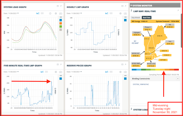
Here are the costs, 7th decile, and trending toward the 8th decile ($201 - $500 / MWh):
Here is the fuel mix:
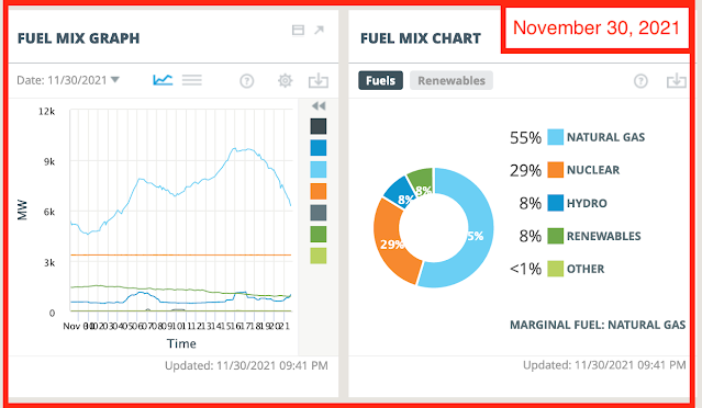
What jumps out at you when you compare the "costs" with the "fuel mix"?

A reader posits the following to explain this phenomenon:

As I also have been closely following the New England electricity 'drama',  I have been a little puzzled as to why the spot pricing has been so high between ~1 AM and ~6 AM as the demand is relatively low. 
Although not 100% certain, I think I understand what is unfolding.

Components ...
1. Day Ahead/Cleared pricing
2. Status of 'Renewables' (sic) ... if the wind be 'ablowin'
3. Temperature (translates into the price AND availability of natgas)
4. Competitive game of 'chicken' amongst hydro, natgas, coal, and oil burning generators

Summary (includes a bit of informed speculation) ... 
1. The Day Ahead pricing (can be seen on the chart 'LMP Map: Real Time' by clicking non-default tab 'Day Ahead' tab which is next to default 'Real Time' tab) is what the ISO folks contract with the various generators as to how much, and at what price, electricity will be available at that time on the next day. These are 'micro sliced' into 5 minute increments.
This amount is reflected by the green line in the first chart 'System Load' and labelled 'Cleared'.

2. The wind contribution (sic) has been relatively low these past few weeks (this has been a BIG contributing factor in Europe's and the UK's current predicament ... grossly under reported by MSM).
This can easily be seen, albeit not in detail, in the 'Fuel Mix Graph' by the green line. (Precise amounts can easily be found by clicking the non-default setting of the 3 grey horizontal lines which is next to the default 'graph' setting [right angle with squiggly line]. The precisely generated amounts are displayed in ~10 minute increments and labelled by source, ie., nuclear, wind, NaturalGas LandfillGas, etc.).

3. Now, come midnight to, say, 6 in the morning, the temperatures have been cold throughout New England these past few weeks.
Consequences? Very high consumption by customers for heat-generating purposes. This is crucial ... the customers of natgas get priority for the available natgas - they have paid for the pipes via their monthly billings. About 5 1/2 Bcfd flows into New England. Power plants reliant upon piped natgas simply cannot be guaranteed supply. Some DO have onsite, back up fuel oil, but this is both limited and expensive.
Bottom line, look to 10 day temperature forecasts to sense the overnight electricity pricing.
Wind forecasts also play a role, but - my experience - far from precise.

4. Power generators (hydro versus oil-burners) can bid against one another to obtain as high a price as they can in the Spot Market while also satisfying reliability requirements of ISO, that is, they are able to generate electricity on short notice.
If you look at the current 'Fuel Mix Graph', you will see a tiny input at the 5 and 8 AM times for 'Oil' sourced.
Likewise, the high price spikes on the 'Five Minute Real-Time LMP Graph'  coincides with the input spike in 'Hydro' production.
Essentially, any provider of electricity will jump in and produce if the fuel is available (natgas/fuel oil/coal) AND a profitable outcome is achievable.

Bottom bottom line ... the New England folks have boxed themselves into an extremely precarious corner whereby they are now competing - with a global market, no less - for means of 'normal' electricity supplies (forget about affordable ... way too late), and this is highly dependent upon weather conditions.
This is EXACTLY what Australia, California, Germany, AND the UK have all experienced or are right now experiencing.

That it seems to be coming as a surprise is, in itself, the biggest surprise.

No New Permits; Two Sinclair DUCs Reported As Completed -- November 30, 2021

Active rigs:

$66.68
11/30/202111/30/202011/30/201911/30/201811/30/2017
Active Rigs3114576654

No new permits
.

One permit renewed:
  • 33206, NP Resources, Mosser Federal 143-102-22-15-4H, Billings County
Two producing wells (DUCs) reported as completed:
  • 36791, 968, Sinclair, Harris Federal 4-32H, Lone Butte, lot 2 section 5-146-97; no other data,
    • in this section there are two Sinclair pads
    • one pad runs west to east, eight wells
    • the other pad runs roughly north to south, with three wells
  • 36792, 1,629,Sinclair, Harris Federal 3-2H, Lone Butte, no other data,

Sinclair wells sited in section 5-146-97:

  • 33426, 33-025-0277, conf, Sinclair, Crosby Creek 7-5TFH, Little Knife,
  • 33425, 33-025-0276, loc, Sinclair, Crosby Creek 6-5H, Little Knife,
  • 36790, 33-025-03883, loc, Sinclair, Harris Federal 30-32H, Lone Butte,
  • 36791, 33-025-03884, 968, Sinclair, Harris Federal 4-32H, Lone Butte,
  • 36792, 33-025-03885, 1,629, Sinclair, Harris Federal 3-32H, Lone Butte,
  • 33424, 33-025-03275, drl/NC, Sinclair, Crosby Creek 5-5H, Little Knife,
  • 36793, 33-025-03886, drl/NC, Sinclair, Crosby Creek 2-32H, Little Knife,
  • 32461, 33-025-03102, drl/NC, Sinclair, Crosby Creek 4-5H, Little Knife,


  • 19304, 174, SInclair, Crosby Creek 1-5H, Little Knife, t11/11; cum 180K 8/21; off line 9/21; 
  • 23459, 1,358, Sinclair, Crosby Creek 2-5H, Little Knife, t12/12; cum 138K 7/21; F; off line 8/21; remains off line 9/21; 
  • 25303, 103, Sinclair, Crosby Creek 3-5H, Little Knife, t9/13; cum 238K 8/21; F; was off line for mjuch of 9/21;

The definitive active rig report:

  • the NDIC reports 32 active rigs and, yes, there are 32 rigs and 32 sites listed;
  • however, CLR's H&P 492 is counted twice, once on LCU Ralph 4-27H (#37013) and also once on LCU Ralph 3-27H1, so, in fact, assuming no other errors, only 31 active rigs;
  • Kraken is not on the list

Kraken's Red, White, And Blue Wells In Divide County -- November 30, 2021

FracFocus posts frack data well after the fact, or however one wants to say that.

But because the NDIC is not updating their data, we may end up using FracFocus as another way to try to keep track of what's going on in the Bakken.

To the best of my knowledge, FracFocus is chronologic, in other words, the API numbers which FracFocus uses, are chronologic by state. 

If that's true, then the most recent data for a fracked well, as of November 29, 2021, is:
33-105-05244, Kraken, Red 22-15 1H, 

Kraken's "Red" wells are up in Burg oil field, north of Williams County, in Divide County.

  • 36652, 897, Kraken, Red 22-15 1H, Burg, t11/19; cum 190K 9/21;

That's the only Kraken Red well the NDIC has posted.

Let's go back one API number: 33-105-05243:

33-105-05243, Kraken, White 23-14 1H, 

  • 36651, 1,017, Kraken, Whiite 23-14 1H, Burg, t11/19; cum 202K 9/21;

And from there:

  • 36650, 779, Kraken, Blue 26-35 1TFH, Burg, t11/19; cum 188K 9/21;

CLR Looks To Have Thirteen Wells On This Drilling Unit -- Cedar Coulee -- CLR Well With Jump In Production -- November 30, 2021

This is a case, not a permit, from the October, 2021, hearing dockets.

Case 29020, CLR, Cedar Coulee-Bakken; thirteen wells on an existing 1280-acre unit, section 33-147-96 and section 4-146-96; Dunn County.

Existing producing wells in this drilling unit:

  • 16797, IA/108, CLR, Bang 1-33H, Cedar Coulee, t4/08; cum 168K 6/21; off line 7/21 - 8/21; remains off line 9/21; NDIC not updating their maps or data bases; is it possible CLR is already drilling new wells in this unit? Or re-fracking a neighboring well?
  • 18636, 633, CLR, Bang 2-33T, Cedar Coulee, t5/10; 219K 9/21; off line 7/21 - 8/21; back on line 9/21 with a nice jump in production; re-fracked; or neighboring wells being fracked; the jump in production is not big enough to suggest a re-frack; suggests neighboring wells being fracked; sundry forms unhelpful; stripper well designation, January 20, 2018;
PoolDateDaysBBLS OilRunsBBLS WaterMCF ProdMCF SoldVent/Flare
BAKKEN9-202126427845146376417838500
BAKKEN8-20216386053685274480
BAKKEN7-20212001320
BAKKEN6-20213064180919710146090
BAKKEN5-202131711100424710856760
BAKKEN4-20213071347419510936880

******************
Wow, Wow, Wow

There it is. CLR is drilling new Bang wells in this drilling unit and the NDIC map is not being updated. Amazing. 

See the "definitive active rig report" being reported by the "milliondollarway" blog because NDIC is not updating their map. 

And it appears the "28606" is a typo. That should be "38606," and, of course no scout ticket.

And here it is, the graphic, with the CLR Bang wells that are apparently being drilled. I think there was a jump in production, and the neighboring wells haven't even been fracked yet. Because there is no scout ticket, I don't have the API number which means I can't see whether this well has been fracked or not.

A Closer Look Where MRO May Have Upwards Of Thirty-One Wells Along One Section Line -- November 30, 2021

The case, this is a case, not a permit:

  • Case 29040, MRO, Bailey-Bakken, fourteen wells on a standup 2560-acre unit; sections 6/7/18/19-146-94; Dunn County; 

This one is interesting. There are already sixteen wells along the section line between section 7 and section 18 but those would be 1280-acre spacing. So I assume these fourteen wells are in addition to the sixteen locations already permitted.

Current locations and active wells:


29040, MRO, Bailey-Bakken, fourteen wells on a standup 2560-acre unit; sections 6/7/18/19-146-94; Dunn County;

Sites and wells:

  • 17537, 503, MRO, David Beck USA 24-7H, Bailey, t12/08; cum 391K 9/21;


  • 17493, 104, MRO, David Beck USA 34-7H, Bailey, t8/09; cum 257K 9/21;


  • 16666, 502, MRO, Bob Tuhy USA 44-19H, Bailey, t11/08; cum 488K 9/21; this well was a relative low producer, until 6/15 when it had a jump in production from 1500 bbls/month to over 14,000 bbls / month;
  • 38044, loc, MRO, Millie USA 21-18H, Bailey,
  • 38043, loc, MRO, Pavlish USA 11-18TFH, Bailey, 
  • 38042, loc, MRO, Reems USA 14-7H, Bailey, 
  • 38041, loc, MRO, Terrel USA 24-7TFH, Bailey, 
  • 38040, loc, MRO, TRU USA 24-7H, Bailey, 
  • 16807, 305, MRO, George Tuhy 11-18H, Bailey, t2/08; cum 184K 9/21;


  • 38045, loc, MRO, Magdalena USA 21-18TFH, Bailey, 
  • 38017, loc, MRO, Bean USA 31-18H, Bailey, 
  • 38018, loc, MRO, Borrud USA 31-18TFH, Bailey, 
  • 38019, loc, MRO, Chester USA 41-18TFH, Bailey, 
  • 38020, loc, MRO, Ellis USA 34-7TFH, Bailey, 
  • 38021, loc, MRO, OTT USA 44-7TFH, Bailey, 
  • 38022, loc, MRO, Sallie USA 44-7H, Bailey,

If these are all 1280-acre spacing, then there will be fourteen more wells along this section line. Overwhelming.