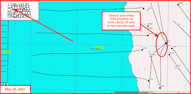
EOG with six new permits, #38326 - #38331, inclusive:
- Comments: EOG has permits for six Liberty LR permits
- four of them will be sited in NWSE 23-151-91; two will be sited in NWNE/NENW 26-151-91;
- the four in section 23 will be sited between 2465' FSL and 2330' FEL and 1025' FSL and 2300' FEL
- the
two (#38330, #38331) in section 26-151-91 will be sited in exactly the
same spot, 1200' FNL and 2350' FWL according to the NDIC daily activity
report, but that is incorrect according to the scout ticket:
- 38331, Liberty LR 125-2629H, 1150 FNL 2350 FWL
- 38330, Liberty LR 66-2629H, 1200 FNL 2350 FWL
The six new permits:
- 38326,Liberty LR 59-2320H,
- 38327,Liberty LR 121-2320H,
- 38328,Liberty LR 123-2320H,
- 38329,Liberty LR 62-2329H,
- 38330,Liberty LR 66-2629H,
- 38331,Liberty LR 125-2629H,
Producing wells and permitted sites in these two sections:
- 19720, 510, EOG, Liberty LR 14-23H, Parshall, t4/11; cum 310K 3/21;
- 30593, loc, EOG, Liberty LR 29-2321H, Parshall,
- 30594, loc, EOG, Liberty LR 108-2321H, Parshall,
- 30595, loc, EOG, Liberty LR 30-2321H, Parshall,
- 19721, 1,063, EOG, Liberty LR 19-23H, Parshall, t3/11; cum 404K 3/21; F;
- 18971, 894, EOG, Liberty LR 09-23H, Parshall; 320-acre spacing, t9/10; cum 258K 3/21;
- 26601, 1,045, EOG, Liberty LR 27-23H, Parshall, t3/14; cum 222K 3/21;
- 26602, IA/1,135, EOG, Liberty LR 28-23H, Parshall, t3/14; cum 215K 3/20; offline;
- 20255, 892, EOG, Liberty LR 15-26H, Parshall, t4/12; cum 389K 3/21;
- 20254, 980, EOG, Liberty LR 20-26H, Parshall, t12/11; cum 357K 3/21; huge jump in production, 3/21;
- 18065, AB/369, EOG, Liberty LR 100-26H, Parshall; 320-acre spacing, t8/10; cum 100K 1/19;
The graphics:
