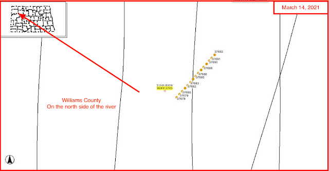
Updates
July 12, 2021: fourteen XTO HBU Marmon / Marmon Federal permits were all renewed this date.
The XTO HBU Marmon Federal Permits/Wells
The permits / wells:
- 18143, 1,065, XTO, HBU Marmon 41X-12, API: 33-105-01735, Hofflund, t9/09; cum 191K 4/20; off line 5/20;
- 37678, conf, XTO, HBU Marmon Federal 24X-13AXD-S, Hofflund,
- 37679, conf, XTO, HBU Marmon Federal 24X-13E-S, Hofflund,
- 37680, conf, XTO, HBU Marmon Federal 24X-13A-S, Hofflund,
- 37681, conf, XTO, HBU Marmon Federal 24X-13F2-S, Hofflund,
- 37682, conf, XTO, HBU Marmon Federal 24X-13B-S, Hofflund,
- 37683, conf, XTO, HBU Marmon Federal 24X-13AXD-W, Hofflund,
- 37684, conf, XTO, HBU Marmon Federal 24X-13E-W, Hofflund,
- 37685, conf, XTO, HBU Marmon Federal 24X-13A-W, Hofflund,
- 37686, conf, XTO, HBU Marmon 24X-13F2-W, Hofflund,
- 37687, conf, XTO, HBU Marmon 24X-13B-W, Hofflund,
- 37688, conf, XTO, HBU Marmon 24X-13G-W, Hofflund,
- 37689, conf, XTO, HBU Marmon 24X-13C-W, Hofflund,
- 37690, conf, XTO, HBU Marmon Federal 24X-13H2-W, Hofflund,
- 37691, conf, XTO, HBU Marmon Federal 24X-13D-W, Hofflund,
- 37692, conf, XTO, Marmon Federal 24X-13HXE-W, Hofflund,
Graphics:
***********************************
Production and File Report: 18143
Production:
- from the outset, a lousy well; max production, 14K in first 29 days, 9/09
- typical Bakken decline
- no evidence this well has been re-fracked as of 4/20
From the file report:
- most recent sundry form, received May 2, 2019, name change: from Marmon 41X-12 to HBU Marmon 41X-12;
- last note before that one, December 8, 2018: stripper well determination;
- April 7, 2017: workover;
- May 15, 2013: company's intent to re-frack;
- sundry form frack data:
- lateral 1 open hole
- 1 million lbs 20/40 sand and 21K bbls frack fluid;
- average treating pressure was 7,968 psi; max of 9,006 psi
- ten stages using swell packers
- September 3, 2009: IP: 1,065 bbls
- target: Three Forks
- geological well report
- spud: June 30, 2009
- designed as a single lateral in the Three Forks;
- secondary zones of interest: Ratcliffe, Mission Canyon, and middle Bakken;
- Three Forks drilled at a measured depth of 10,469', TVD = 10,589'; 34' low to the prognosis and 34' low to the Marmon 9-1 control well;
- initially, the gas readings were generally poor, averaging 100 to 200 units, except from 11,350' to 11,500' where fair to good shows from 500 to 2000 units were recorded
- from 11,800' to 14,175' gas shows were generally good averaging 500to 4000+ with connection kicks reaching 5000 to 6000 units
- 2' to 5' flare
- Ratcliffe and Mission Canyon not productive in this well
************************************
From The Daily Activity Report
July 2, 2020
Fifteen new permits, #36578 - #37692, inclusive:
- Operator: XTO
- Field: Hofflund (Williams County)
- Comments:
- I believe the daily activity report is incorrect
- the DAR says these wells are sited in section 13-154-96; if so, they are being sited under water
- in addition, the legal description for #37685 is incorrect; the scout ticket is correct;
- it's much more likely these wells will be sited in section 13-154-95
- XTO has permits for fifteen wells in section 13-154-96 (sic) -- see comments above
- Hofflund Bakken Unit (HBU)
- fourteen of them are Hofflund Bakken unit wells; one had the same "family" name, but not preceded by the HBU designation; it was in the Alkali Creek oil field;
- one long single row of pads, running almost due north/south, but slightly SW to NE, very slightly off the N/S line
- running from the SESW quadrant to the NESW quadrant
- they are already on confidential list but based on several parameters, it's my hunch they will all run south into section 24
- thirteen will be 1280-acre spacing
- two will be 2560-acre unit line wells
- it looks like: a mix of middle Bakken well and Three Forks wells
- graphics:


