Re-posting. This might be the biggest story of the week and it's only Sunday.
Sour grapes: Saudi Aramco is seeking to review price of SABIC deal. Wow. Are you kidding? My hunch: the fix is already in. At Reuters:
Saudi Aramco is looking to restructure its deal to acquire a controlling stake in petrochemicals maker SABIC after a more than 40% drop in SABIC’s value following a slump in oil prices in coronavirus pandemic.
- transaction priced at 123 riyals; $70 billion share of SABIC; represented 70% of SABIC;
- today: shares trading at 70 riyals; entire SABIC now valued at less than $60 billion; Aramco's stake now worth about $40 billion
- ouch
**********************************
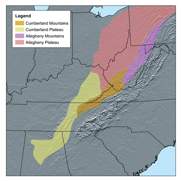
The Geography Page
Subdivisions Of The Southern Appalachian Plateau
To help me understand the history of the Scotch-Irish / Ulster-Scots in America. Very, very broad-brushed; very simplistic; and probably filled with errors, but it gets me oriented to a part of the United States I don't know well.
Various links. A very generalized map at this link.
From north to south, and then east to west:
- Allegheny
- Allegheny Mountains (southwest PA, and eastern third of WV)
- Allegheny Plateau (eastern half of OH; western two-thirds of WV)
- Cumberland
- Cumberland Mountains (southeast corner of WV; southwest border of Kentucky/Virginia)
- Cumberland Plateau (eastern fifth of Kentucky; eastern sixth of Tennessee; into Mississippi
- Allegheny Mountains, maybe
- from Pittsburgh, PA, to Charleston, WV; maybe 200 miles as the crow flies?
- Cumberland Mountains, maybe
- from Charleston, WV, to Knoxville, TN; maybe another 200 miles as the crow flies?
- the Allegheny Plateau, in a northeast to southwest orientation, extends from western PA and western WV to eastern half of Ohio; a very little bit of northeastern Kentucky;
- the Cumberland Plateau, in the same northeast to southwest orientation, from a small eastern fifth of Kentucky, a small eastern sixth of Tennessee, and down into north-central Mississippi, skirting a bit of the northwestern corner of Alabama
- the northern route took them into Ohio
- the southern route took them into Tennessee
I have two wonderful memories of this area but at the time did not realize the significance of this incredibly beautiful area.
First trip through this area, Nashville, TN, to Westfield, NJ, early summer, 1971, mostly through the night; leaving Nashville, TN, early afternoon, and arriving Westfield, NJ, very early the next morning. The more I think about that trip, the more amazing it was.
Second trip through this area, Langley AFB, VA, to Wright-Patterson AFB, Dayton, OH, summer, 2001, if I recall correctly. A most spectacular drive through the mountains of West Virginia. Based on my notes above, they would have been the Allegheny Mountains, and maybe even the northeastern tip of the Cumberland Mountains: I-64 to Charleston, and then US Highway 35 through western VW and southeastern Ohio up to Dayton, OH.
Early western settlements at this site.
The Great Shenandoah Valley linked the northern and southern portions of the area sometimes called the “Old West.” In the North, this inland region extended across Pennsylvania and New York as far as Lake Champlain. In the South, the “Fall Line” formed the separation between the Tidewater settlements and the Piedmont which sloped gradually upward towards the Appalachian Mountains. Through the Valley, the Germans and the Scots-Irish migrated in unending procession.
Southern settlers from Maryland and Virginia moved along the Potomac River north and west to Fort Cumberland and then to Pittsburgh and Ohio country. Alternately, some went through mountain passes into Kentucky and Tennessee. Still others continued south and west into Georgia, Alabama, Mississippi, and Florida.That's enough now to get me oriented and get me started.
Re-reading: The Scotch Irish: A Social History, James G. Leyburn, c. 1962.